
To give answers to those questions, the working plan has been
designed around three main objectives:
1. IDENTIFY and CHARACTERIZE the accumulation of
water vapor and secondary air pollutants in the western
Mediterranean, and their interrelationships with episodes of
atmospheric secondary pollutants and the occurrence of convective
and orographically aided summer storms (so-called colloquially
"summer storms ").
2. ANALYZE the sensitivity of recharge processes
(or feedback processes) of water vapor in the western
Mediterranean basin to disturbances caused by climate change.
3. TRANSFER the results obtained implementing them
into the surveillance and early warning systems on environmental
(atmospheric) risks at the Valencian Community (extreme
temperatures , heavy rains and secundary pollution episodes).
To optimize the configuration of meteorological meso-scale models run in the region to get better forecasts of topographycally-aided summer storms, VERSUS project follows two complementary approaches:
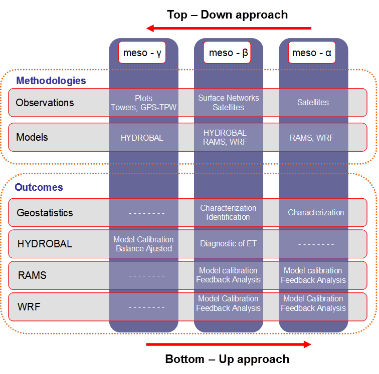
From a bottom-up approach, VERSUS aims to characterize the
seasonal time-evolution of the evapotranspiration along the Turia
Valley by means of measuring at different plots along the valley
and by modelling the hydrological balance at the landscape scale
and, coherently, upscaling to the whole basin scale. One of the
main outcomes to be compared with the products obtained from the
top-down approach is the apportionament of water vapor coming from
the evapotranspiration under different meteorological conditions
during the season of topographycally-aided summer-storm formation.
From a top-down approach, the numerical modelling tools run in the
project will assimilate experimental data to reach realistic
mixing ratio values along the Turia Valley and to appraise the
land use as a key component to the reach the critical thershold
for the topographycally-aided summer storm formation.
 |
|
|
National R&D&I Plan Project: CGL2015-67466-R |
|
| Project funded by | |
  |
|
| Mediterranean SST | |
 |
|
| Monitoring site | |
 |
|
| Tweets por el @CEAM_Meteo. | |
| Latest news | ||
|---|---|---|
|
||